Rio De Janeiro
Jammed into the world's most beautiful setting - between ocean and escarpment - are 7 million Cariocas, as Rio's inhabitants are called.
Rio has its problems, and they are enormous: a third of the people live in the favelas (shanty towns) that blanket many of the
hillsides; the poor have no schools, no doctors, no jobs; drug abuse and violence are endemic; police corruption and brutality
are commonplace.
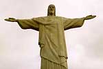
The view from the top of Corcovado, the 750m (2460ft) mountain peak with the statue of Christ the Redeemer at its summit,
offers the best way to become geographically familiar with the city. Copacabana is probably the world's most famous beach, and
runs for 4.5km (3mi) in front of one of the most densely populated residential areas on the planet. Pão de Açúcar (Sugar Loaf)
is God's gift to the picture-postcard industry. Two cable cars climb 396m (1300ft) above Rio and the Baía de Guanabara and,
from the top, Rio looks the most beautiful city in the world.
Web: en.wikipedia.org/wiki/Rio_de_Janeiro

Pantanal
The term Pantanal is applied to a large land mass which becomes partially submersed during the raining season, covering an area
of about 210,000 square kilometers in Central-Western Brazil, Eastern Bolivia and part of Paraguay. The largest portion of
Pantanal, about 140,000 square kilometers lies, in Brazil, stretching over two states-- Mato Grosso and Mato Grosso do Sul.
By comparison, Florida Everglades has only 10,000 square kilometers.
In the Pantanal region occur around 700 species of birds (compared to about 500 in all Europe). It is one of the most important
breeding grounds for typical wetland birds such as heron, stork, ibis and pink spoonbill that are found in enormous flocks.
The magnificent Jabiru with its red neck and black head; the biggest stork of the Americas is known as the symbol of the
Pantanal. Quite evident are also the 26 species of parrot including the endangered blue hyacinth macaw, the world's largest
parrot more than one meter long. Of other characteristic birds can be mentioned the rhea - the South American version of the
ostrich. The large quantity of birds of prey - represented by 45 species - indicates a well balanced ecosystem.
Web: en.wikipedia.org/wiki/Pantanal

Iguazú Falls
Situated in the Parque Nacional Iguazú near Puerto Iguazú, the spectacular Iguazú Falls (a Guarani name meaning 'Great Waters')
lie just east of the confluence of the Iguazú and Paraná rivers.
The falls are made up of 150-270 subsidiary falls depending on the flow rate, which seasonally varies between 300 cu.m/sec. and
6,500 cu.m/sec..
The falls form a semi-circular front of 2,700m, of which 800m is under Brazilian jurisdiction. A proliferation of elongated
islands, islets and rocks create numerous waterfalls which together form the large fan of the Iguazú Waterfalls.
The falls drop an average of 72m and the river immediately turns into a narrow, 80m deep canyon, which has been enlarged by
erosion of the basalt bedrock.
The falls were probably initially located at the confluence of the Iguazú and Parana Rivers some 20,000 years ago, but erosion
has caused them to recede 28km upstream to their present location.
The best time of year to see them is from August to November, when
there is least risk of flood waters hindering the approach to the catwalks. Above the falls, the waters are suitable for canoeing,
kayaking and other water sports. The surrounding park is home to 55,000 hectares (135,850 acres) of pristine subtropical
rainforest, with abundant wildlife and plant species.
Web: en.wikipedia.org/wiki/Iguazu_Falls
Valdes Peninsula
The Valdés Peninsula is located at the northeastern tip of Patagonia. It literally juts into the Atlantic Ocean. It is linked to
the mainland by an isthmus a few miles wide and (with a curious axe like shape) has a vast length of ocean shores.
Centuries of erosion have formed rocky shelves, gulfs, bays and sandy and rocky beaches, each of which is a natural shelter for
marine mammals and birds.
The mixing of the warm Brazilian Current with the cold Malvinas Current favors the thriving of plankton, algae and shellfish.
This in turn constitutes the basis of the food chain for large numbers of species of marine wildlife.
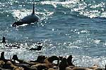
Sea lions, elephant seals, right whales, orcas, dolphins, Magellanic penguins and tens of species of birds are present in huge
colonies all around the Peninsula.
The landscape is for the most part dry and desolated. The prevailing vegetation is the tundra like Patagonian desert steppe.
Some 130 plant species from 41 families have been reported, with 38 species native of Argentina.
Animals such as guanacos, lesser rheas, Patagonian foxes, maras, hairy armadillos inhabit and can be found in the area.
Web: en.wikipedia.org/wiki/Valdes_Peninsula
Torres del Paine National Park
Situated 145 km northwest of Puerto Natales and covering 181.414 hectares, the national park Torres Del Paine, a Unesco
Biosphere Reserve, is a must for its wildlife and spectacular scenery. The scenery is superb, with constantly changing views
of fantastic peaks, ice-fields, vividly coloured lakes of turquoise, ultramarine and grey, and quiet green valleys.
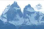
Without doubt, one of the major attractions of the park is the Paine Massif, mostly composed of granite, and originated 12
million years ago. The highest peak is the Paine Grande (3050 m), although the most representative peaks are the "Cuernos del
Paine" (horns) featured on most pictures of the park. The Torres del Paine are three sheer granite towers, that make a challenging and
coveted prize for climbers.
Web: en.wikipedia.org/wiki/Torres_del_Paine_National_Park
Perito Moreno Glacier
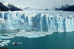
Perito Moreno Glacier, in the southern area of the Los Glaciares National Park, is the most important and most easily reached
glacier. This is an imposing ice river, 3 km in width and 60 m in height, that descends slowly from the Hielo Continental
Patagonico (Patagonian Continental Ice) to the shore of the lake, in the Canal de los Tempanos (Icebergs Channel).
Only 200 m above sea level, it has turned into the biggest attraction of the region thanks to its spectacular beauty, its
glacial interest and its different behavior to the rest of the glaciers of the world.
It is a white giant that, moving noisily, offers an incredible scenery. During its slow advance, it blocks the Canal de los
Tempanos, forming an ice dam that does not allow the drainage of the waters of the South Arm to the central part of the lake.
The pressure of the water trying to recover its natural course increases from year to year until it starts to pierce the front
of the glacier, producing the famous "fracture".
This is a unique spectacle that repeats itself every 4 or more years where tons of ice yield to the force of the water.
This process lasts up to 36 hours; peace and silence return afterwards.
Web: en.wikipedia.org/wiki/Perito_Moreno_Glacier

Fitz Roy Range
The extreme north of Los Glaciares National Park is dominated by an imposing group of granite mountains, featuring the
Fitz Roy Range and the Torre Range. Their summits, which are celebrated in the world of mountain climbing, tower more than
9000 feet (3000m) above sea level. Agressively jutting up from the earth, they can be seen from several miles away.
The aboriginal population named Mount Fitz Roy 'Chaltén', which means 'mountain that sends out smoke', since they believed it
was a volcano. Accompanied by the spiraling Poincenot and other adjacent peaks, it is one of the most well-known images of
Patagonia. Mount Torre, with its impressive slopes and permanently snow-capped summit, has always represented an especially
difficult challenge even for world-class mountain climbers due to its violent and unpredictable climate.
Web: en.wikipedia.org/wiki/Fitz_Roy
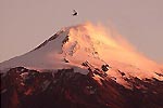
Mt. Villarica near Pucon
This beautiful mountain (2.847 mt/ 9.340 ft) has a classic volcanic cone crowning the surrounding countryside. The volcano has
erupted repeatedly during the last century, the most recent eruptions registered in 1971 and 1984. Despite its continuing
activity, Villarica is the most climbed peak in southern Chile. The ascent of Volcan Villarica is technically very
straightforward, although it demands good fitness.
The crater at the summit offers a spectacular panorama: molten magma boiling out of openings in the volcano core and a superb
view of virtually every major peak in the northern Lake District.
Web: en.wikipedia.org/wiki/Villarrica_(volcano)

Atacama Desert
The Atacama desert in Chile is the driest desert in the world. There are parts of it where rain has never been recorded and the
precious little precipitation (1cm/0.3in per year) that does fall comes from fog. Flanked on one side by Pacific coastal ranges
and on the other by the snowcapped peaks of the Andes, the desert is a series of salt basins that support virtually no
vegetation.
Close to San Pedro is the Reserva Nacional Los Flamencos, which boasts, among other attractions, Chaxa Lagoon, home to a
flamingo breeding colony. Around the same region is the Valle de la Luna (Valley of the Moon), whipped peaks of salt and sand.
North of this is the 150m (490ft) deep Chiu-Chiu lagoon, an astonishing natural phenomenon in the middle of the desert.
Go even further north and you'll hit the amazing El Tatio Geysers. At 4300m (14,000ft) above sea level, it's the highest geyser
field in the world. The sight of the earth steaming away like a kettle on the boil, with the rising sun in the background,
is worth an early morning call.
Web: en.wikipedia.org/wiki/Atacama
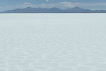
Salar de Uyuni
This 9,000 km (4680 sq mi) salt desert at an altitude of 3650m (11,970ft) is the largest salt flat in the world. It was once
part of a prehistoric salt lake which covered most of southwestern Bolivia. Armed with only picks and shovels, the local
campesinos harvest salt from this ancient lake filled with an estimated 10 billion tons of fine salt.
Situated in a semi-arid climate, the Salar has an average annual rainfall of about 10 inches. During the rainy season, from
December to March, the Salar maybe covered with salt water to depths of 25 cm; however during the dry season, the salt water
evaporates to a layer above or below the surface.
Web: en.wikipedia.org/wiki/Salar_de_Uyuni
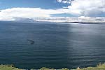
Lake Titicaca
Lake Titicaca is the world's highest navigable lake and the center of a region where thousands of subsistence farmers eke out a
living fishing in its icy waters, growing potatoes in the rocky land at its edge or herding llama and alpaca at altitudes that
leave Europeans and North Americans gasping for air.
This, the most sacred body of water in the Inca empire and now the natural separation between Peru and Bolivia, has a surface
area exceeding 8,000 square km (3,100 square miles), not counting its more than 30 islands.
At 3,856 meters (12,725 feet) above sea level it has two climates: chilly and rainy or chilly and dry.
According to legend, this lake gave birth to the Inca civilization. Before the Incas, the lake and its islands were holy for the
Aymará Indians, whose civilization was centered at the Tiahuanaco, now a complex of ruins on the Bolivian side of Titicaca but
once a revered temple site with notably advanced irrigation techniques.
Geologically, Titicaca's origins are disputed, although it was likely a glacial lake. Maverick scientists claim it had a
volcanic start; a century ago, Titicaca was popularly believed to be an immense mountaintop crater. A few diehards today stick
to the notion that the lake was part of a massive river system from the Pacific Ocean.
Puno is the stepping-off point for exploring Titicaca with its amazing array of islands, Indian inhabitants and colorful
traditions.
Web: en.wikipedia.org/wiki/Lake_Titicaca
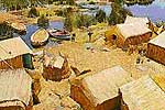
Floating islands on Lake Titicaca
The best-known of the islands dotting Titicaca's surface are the Uros, floating islands of reed named after the Indians who
inhabited them. Legend has it the Uro Indians had black blood that helped them survive the frigid nights on the water and
safeguarded them from drowning. The last full-blooded Uro was a woman who died in 1959. Other Uros had left the group of
islands in earlier years owing to a drought that worsened their poverty - and intermarried with Aymará and Quechua-speaking
Indians. But the Indians who now inhabit this island - a mix of Uro, Aymara and Inca descendants - follow the Uro ways.
The Uros islanders fish, hunt birds and live off lake plants. The important element in their life being elake reeds they use for
their houses, boats and even as the base of their five islands - the largest of which are Toranipata, Huaca Huacani and Santa
Maria. The bottoms of the reed islands decay in the water and are replaced from the top with new layers, making a spongy surface
that is a bit difficult to walk on. Even the walls of the schools on the bigger islands are made of totora. The soft roots of
the reed are eaten, making it a pretty handy thing to have around.
Web: en.wikipedia.org/wiki/Uros

Amantani/Taquile
Amantani, a lovely and peaceful island, was once part of the Inca empire and has opened its doors to outsiders who are willing
to live for a few days as the Aymará-speaking islanders do -and that means sleeping on beds made of long hard reeds and eating
potatoes for every meal. There is no running water or electricity and night time temperatures drop to freezing even in the
summer. But those happy to rough it catch a glimpse of an Andean agricultural community that has maintained the same traditions
for centuries. Some Amantaní residents live and die without ever leaving the island.
Prepared visitors usually bring gifts of fruit - a rarity on the isolated island and the socializing begins when a family member
who speaks English offers a guided walk around the island, from where the views are something spectacular. Women wearing
traditional black and white lace dresses pass by with Islingshots in their hands to kill scavenging birds.
At night you will join the residents in the common room for music and dance.
As numerous as the dances themselves are the lavish and colorful outfits the dancers wear. They range from multi-hued polleras
(layered skirts) donned by barefoot female dancers to the short skirts, fringed shawls and bowler hats used in the highland
version of the marinera dance. For centuries the Indians in the altiplano were accustomed to working hard, then celebrating
their special days with gusto. In fact, many of the dances incorporate features of the most repressive times for the Indians
with dancers dressed as mine overseers or cruel landowners characters that are mocked during the festivities.
Another island that lures tourists is Taquile, the home of skilled weavers and a spot where travellers can buy wellmade woolen
and alpaca goods as well as colorful garments whose patterns and designs bear hidden messages about the wearer's social standing
or marital status.
Web: en.wikipedia.org/wiki/Amantani
Web: en.wikipedia.org/wiki/Taquile_Island

Machu Picchu
The Citadel of Machu Picchu (in Quechua language " Old Mountain") is known throughout the world for its amazing ruins and its
unusual location on a high mountain overlooking the mighty currents of the Urubamba river.
Even today nobody has been able to solve the mystery how the builders and designers managed to transport the huge blocks of
limestone to the top of the mountain required for the construction of the city.
Probably built during the 15th century in a very difficult location, it is the greatest achievement of the Incas architects due
to the intelligence and dare demonstrated by their design. It has an extent of 13 sq/km and its main functions were military and
religious. It used to be surrounded by an outer wall with a height of 6.00 m. and a width of 1.80 m. and it is estimated that it
was inhabited by 10000 people. Built of limestone (the outer and inner walls), wood (doors and frames), and ceilings made of
straw.
Machu Picchu is located 2300 meters above sea level (7546 ft.), at 112 km. (70 miles) from Cuzco, in the valley of Urubamba in
the lowest part of the Sacred Valley of the Incas in a area of direct access to the upper jungle. Without doubt, Machu Picchu
was part of a very big complex of fortresses which defended the Andean lands in Sacred valley of any assault from native people
out of the jungle.
Having Huayna Picchu as a background they divided Machu Picchu in four sectors. Northwest is located the area that was probably
used for the main religious purposes, that includes a Plaza named by Hiram Bingham as "Sacred Plaza", also the temple of the
"Three Windows", "The Sacred Temple", the "Priests Mansion", and the "Intihuatana" that is a large block of limestone used
during Inca ceremonies.
The "Intihuatana" (in Quechua = place where the sun is bonded) is a solar observatory that allowed the Incas to keep track of the
seasons of the year and the flow of time based on the shadows caused by the sun over the stone.
The largest residences are located on the northeast of the complex. The most luxurious residences and also a watch tower are
located on the southwest of the complex and therefore it is assumed that this part of the Citadel was probably the heart of all
the urban activities.
To the southeast of the complex are located the smallest and most humble of the buildings built around very narrow streets,
close to numerous terraces constructed for agricultural purposes as denoted by the existence of a very complex aqueduct system
in this area. In the lowest part of the terraces is a cemetery, where during a search were discovered 135 skeletons and 109 of
them were identified as females. This fact has allowed historians and archeologists to believe that Machu Picchu's inhabitants
were mostly females that could have been the chosen ones of the Inca, fleeing from Cusco when it was overrun by the Conquerors
of Spain and seeking refuge in Machu Picchu that, by the way, was never discovered by the Spaniards.
Web: en.wikipedia.org/wiki/Machu_Picchu

The Inca Trail
The total length of the Inca Trail in approximately 43 km, leaving from Piscacucho, known as Km. 82. It goes for 4 days and three nights. It
passes several archaeological ruins along the route. At the same time, it crosses 9 different ecological areas which are located
between 2000 and 6000 metres above the sea level.
To start the journey you cross the hanging bridge Kusicancha, then keep to the left by the forest of eucaliptus trees.
The journey starts calmly. You will arrive at Wayllabamba where it is recommended to camp.
The second day is the toughest, you have to climb 4200 meters to the top of Warmiwañusqa (Dead Womans Pass - the highest point).
Afterwards you walk down for about an hour until you reach the valley of the Pacamayo river which is lower and where the next
camp site is located.
The third day is the longest, but the most interesting as you can visit some spectacular sites such as Runkuracay, Sayaqmarca,
Phuyupatamarca and Wiñayhuayna, where the last camp site is located.
The fourth day is the best part of the whole trail, very early in the morning you must start your walk to Inti Punko or Door of
the Sun, where you will be able to see the most amazing sunrise ever; finally you can start descending to the fabulous citadel
of Machu Picchu.
Web: en.wikipedia.org/wiki/Inca_Trail_to_Machu_Picchu

Colca Canyon
The Colca river begins high in the Andes, at Condorama Crucero Alto, drops down to the Pacific in stages, changing its name to
Majes and then Camana as it goes. Where it runs between the tiny mountain villages of Chivay to Cabanaconde is a deep canyon
known as the Colca Canyon.
This canyon is reportedly the deepest in the world, thought to be twice as deep as the Grand Canyon in the USA. Unlike most of
the Grand Canyon, portions of the Colca canyon are habitable, with pre-Colombian terraced fields still supporting agriculture
and human life.
What brings increasingly more visitors each year, in addition to the awesome sights, are the Andean condors. The condor
population of South America is unfortunately dwindling, but here in Colca Canyon, visitors can see them at fairly close range
as they float on the rising thermals and scan for carrion far below them.
Web: en.wikipedia.org/wiki/Colca_Canyon

Nasca lines
The Nasca Lines are one of humanity's mysteries. They are the most outstanding group of geoglyphs in the world. Etched in the
surface of the desert pampa sand about 300 hundred figures made of straight lines, geometric shapes and pictures of animals and
birds - and their patterns are only clearly visible from the air. They were built by people called the Nasca - but why and how
they created these wonders of the world has defied explanation.
The Lines were first spotted when commercial airlines began flying across the Peruvian desert in the 1920's. Passengers reported
seeing 'primitive landing strips' on the ground below. No one knew who had built them or indeed why.
The pebbles which cover the surface of the desert contain ferrous oxide. The exposure of centuries has given them a dark patina.
When the gravel is removed, they contrast with the colour underneath. In this way the lines were drawn as furrows of a lighter
colour, even though in some cases they became prints.
There appear to be two kinds of designs: the first are figures of various beings and things and the others form geometric lines.
The former consists of figures of animals, plants, objects, such as anthropomorphic figures of colossal proportions made with
well-defined lines. Of these figures, which have been restored by Maria Reiche and other collaborators about 70 are known.
In terms of the lines, many kilometers long, they crisscross sectors of the pampas in all directions. Many of the lines form
geometric figures: angles, triangles, bunches, spirals, rectangles, wavy lines, etc. Other lines form concentric circles
converging with or emanating from a promontory. Other prints have formed "roads" like geometric planes and appear to have been
occupied by large groups of the population.
Web: en.wikipedia.org/wiki/Nasca_lines
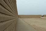
Chan Chan - Chimu Temple City of the Sea
Living in harmony with nature, the Chimu venerated the sea -- Deep in the heart of the Moche Valley and near the Valley of
Trujillo not far from the Pacific ocean, lie the ruins of the largest mud city of pre-Hispanic Peru: Chan Chan. Capital city of
the Chimu kingdom the citadel is without a doubt the most valuable heritage of what was one of the principal pre-Inca
civilizations that flourished eight centuries ago on the northern Peruvian coast.
Chan Chan meaning "Sun Sun," is sprawled across an estimated l8 square kilometers. At the peak of its glory in the year l200 ad,
the city most likely housed nearly l00,000 inhabitants. While the mud used to build the city was far from solid, it was
preserved by the desert climate. Chan Chan must have been the grandest city of its era! Even today, one can make out a variety
of chambers surrounded by high walls. Surrounding these construction's, which have defied the ravages of time, are a dozen
smaller building's used as housing, plazas, workshops, labyrinths and pyramids! The walls, built by slave labor, were
constructed for both privacy and protection from the coastal winds. The extremely large walls were built as high as thirty-three
feet tall. The materials used to create these massive walls were tapia and brick adobe. Similar materials were used in most
of the Chan Chan's architecture. Mud was also used to finish up the outside of the homes. A pattern of sorts would be scribed
into the mud.
Web: en.wikipedia.org/wiki/Chan_Chan